Spatial dissimilarity index

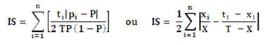
This indicator provides information on the spatial distribution of different population groups. It measures the concentration, or the dispersion, with which persons belonging to these groups are distributed in different spatial units. 

From an integration perspective, a decrease in the spatial dissimilarity index indicates an improved situation.

Definitions

The spatial dissimilarity index developed by Duncan and Duncan measures a group's distribution in spatial units and in theory ranges from 0 (perfectly even distribution) to 1 (maximum segregation distribution).  The index value shows the proportion of the group that would have to be moved to achieve perfectly even distribution in the observed geographic area.

Methodologies

The index is calculated as follows:

With ti = Total population in the spatial unit i; T = Total population in observed area; pi = proportion of group in spatial unit i; P = proportion of the group in observed area; xi = proportion of group X in spatial unit i; X = population from group X in observed area; n= Number of spatial units in observed area.

The political and administrative spatial sub-units on which the calculations are based are neighbourhoods in large towns and communes for cantons and larger urban zones.

Contact

Federal Statistical Office Section Demography and Migration
Espace de l'Europe 10
CH-2010 Neuchâtel
Switzerland

Contact

Remark

Our English pages offer only a limited range of information on our statistical production. For our full range please consult our pages in French and German (top right hand screen).

https://www.bfs.admin.ch/content/bfs/en/home/statistics/population/migration-integration/integration-indicators/social-cohesion/dissimilarity-index.html