
- Cartographic base maps (geometries) of statistical divisions
- As digital basis for thematic mapping
- Vector data for Spatial Information Systems
- Recommended scale for maps: 1 : 500 000 - 1 : 5 000 000
- Perimeter: Switzerland (without the Principality of Liechtenstein)
- Update: annually in early spring
- File Format: ESRI Shape
Offer
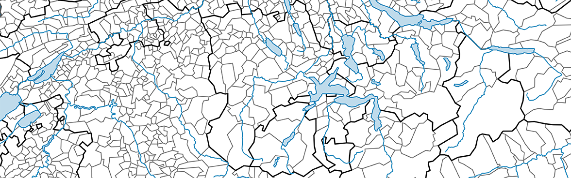
ThemaKart, the FSO cartographic centre, offers numerous map bases (geometries) for most official geographic divisions, which are used in maps and atlases of the Federal Statistical Office. An annually updated set of these geometries is freely available. The Cartographic bases set contains the latest years and the state for the Population Censuses of 2000 and 2010 for the major geographic divisions, plus additional years for communes and districts, polygons for districts within the 17 largest Swiss cities. Total areas are shown in polygons which come in two versions: total area surfaces (gf, Gesamtfläche) and vegetation surfaces (vf, Vegetationsfläche). Additionally, the topographic information is enriched by numeours layers for rivers.
Administrative divisions
Regions for political and spatial planning
Regions for analysis
Spatial typologies
City districts
Topographical layers
| Administrative divisions | Valid from |
|---|---|
| Switzerland | 01.01.1848 |
| Cantons | 01.01.2022 |
| Cantons | 01.01.1997 |
| Districts | 01.01.2023 |
| Districts | 01.01.2022 |
| Districts | 01.01.2019 |
| Districts - at the time of the Popluation Census 2010 | 01.01.2010 |
| Districts - at the time of the Popluation Census 2000 | 05.12.2000 |
| Political communes | 01.01.2024 |
| Political communes | 01.01.2023 |
| Political communes | 01.01.2022 |
| Political communes - at the time of the Popluation Census 2010 | 21.11.2010 |
| Political communes - at the time of the Popluation Census 2000 | 05.12.2000 |
| Political communes | 01.01.2000 |
| Communes (Politics) | 01.01.2024 |
| Communes (Politics) | 01.01.2023 |
| Communes (Politics) | 01.01.2022 |
| Regions for political and spatial planning | Valid from |
|---|---|
| Spatial planning regions | 01.01.2009 |
| Mountain regions 2019 | 01.01.2021 |
| Economic renewal areas (WEG 2001) | 01.01.2001 |
| Areas of tax reductions (ASE 2016) | 01.01.2016 |
| Regions for analysis | Valid from |
|---|---|
| Major regions | 05.12.2000 |
| Language areas 2020 | 01.05.2022 |
| Large labour market areas 2018 | 01.01.2019 |
| Labour market areas 2018 | 01.01.2019 |
| Labour market areas 2000 | 05.12.2000 |
| MS regions | 05.12.2000 |
| Agglomerations and core municipalities outside of an agglomeration 2012 | 01.01.2022 |
| Agglomerations and individual towns | 01.01.2002 |
| Metropolitan areas | 01.01.2005 |
| Touristic regions | 01.01.2020 |
| Spatial typologies | Valid from |
|---|---|
| Urban core areas and areas with urban influence | 01.01.2014 |
| Urban / rural areas | 05.12.2000 |
| Areas with urban character | 01.01.2014 |
| Urban / rural typology | 01.01.2017 |
| Degree of urbanisation (DEGURBA eurostat) | 01.01.2017 |
| City districts | Valid from |
|---|---|
| City districts (17 largest cities) and Political communes | 01.01.2010 |
| City districts (17 largest cities) and Political communes | 05.12.2000 |
| Topographical layers | Valid from |
|---|---|
| Lakes - Category 1 ( > 500 ha ) | - |
| Lakes - Category 2 ( > 195 - 499 ha ) | - |
| Rivers - Category 1 | - |
| Rivers - Category 2 |
- |
| Rivers - Category 3 | - |
| Rivers - Category 4 | - |
| Rivers - Category 5 | - |
| Cantonal capitals | 01.01.2022 |
Download
The Cartographic bases set is freely available for direct download:
Previous free editions of the Cartographic bases set:
ThemaKart map boundaries 2023
ThemaKart map boundaries 2022
ThemaKart map boundaries 2021
ThemaKart map boundaries 2020
ThemaKart map boundaries 2019
ThemaKart map boundaries 2018
ThemaKart map boundaries 2017
ThemaKart map boundaries 2016
ThemaKart map boundaries 2015
ThemaKart map boundaries 2014
ThemaKart map boundaries 2013
ThemaKart map boundaries 2012
Further information, brochure
There is a detailed information brochure with more information on the contents and references behind this offer, as well as a list of nomenclatures used and the application of copyrights (brochure available only in German and French).

